TOPIC: RELIEF AND DRAINAGE OF AFRICA
PHYSICAL FEATURES OF AFRICA
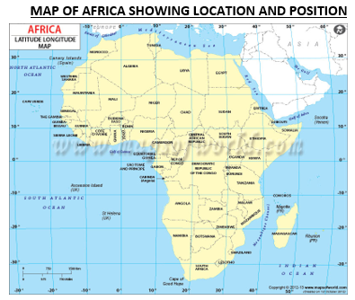
Africa as a whole is simply a vast plateau of ancient rocks with a narrow coastal plain. The plateau has an average height of about 425m in the north and west, while the southern and eastern parts of the continent have an average height of over 900m. above the general levels of the plateau are outstanding rideges and surfaces. In the north are the Ahaggar, Tasilli, Tibesti, and Darfur plateaux. Other examples include the Fouta Jallon and Guinea highlands (900m high) in West Africa. These granitic upland broke the monotony of the plateau.
In some areas, mostly in East Africa, volcanism has helped in building peaks high above the general level of the plateax. Examples of these include, Cameroon mountain (4,070m), the Ethiopian highlands(over 3500m), the Elgon (4321m), Kenyan mountains (5199m) and the Kilmanjaro (5898m), which is the highest peak in Africa.
Folding, although not so pronounced in Africa as in Europe, left some marks on the continent of Africa. In the extreme northwest, folding gave rise to the Atlas mountain ranges. The origin of this range is traced to the folding which occurs in the Alps of Europe.
Folded mountains are also restricted to the extreme part of South Africa. Examples include the Cape range made up of Zwarte, Bergen, Lange Bergen and Oilfants mountains popularly referred to as Drakensberg highlands.
VALLEYS
A striking feature of Africa’s relief is the Great Rift Valley of East Africa. This huge trough, about 5000km long, beings from the Jordan valley and runs southwards through the Red Sea. It then passes through Ethiopia and terminates at lake Malawi, from where a western trough is a result of down-warping of the land between two parallel faults. The East Africa Rift Valley contains a number of long, narrow and deep lakes such as Lake Tanganyika, the world second deepest lake (1435m). Other lakes include Lake Albert, and Lake Edward. Often the course of Rift Valley is traced by strings of lakes.

MAP OF AFRICA SHOWING RIVERS, LAKES AND DRAINAGE SYSTEMS

DRAINAGE
The drainage system of the African continent is a reflection of its plateau character. The great plateau which slopes northwards as far as the Equator is deeply cut into by the basins of the River Congo, River Nile, and the Lake Chad. The basins are separated by plateau such as, the Cameroon mountains in the western limb, the Tibeste, Darfur, Tassile and Ahaggar Plateaux in the central limb and the Ethiopian highlands in the Eastern limb. This result in large parts of Africa being areas of inland drainages. These include:
In addition of these inland drainages are large areas of inland deltas and swamps. They include:
RIVERS
Africa continent is drained by the following Rivers; the Nile 6400km (the longest River in the world), Congo 4,800km, the Niger 4,060km, the Zambesi 2400km, the Orange, 1.920km, the Orange, Gambia and Volta flow into the Atlantic ocean. The Zambesi and Limpopo flow into the Indian Ocean, while the Nile empties into the Mediterranean Sea.
CHARACTERISTICS OF AFRICAN RIVES
LAKES
Lakes in Africa are of three main types. They are as follows:
IMPORTANT OF RIVERS AND LAKES IN AFRICA
THE COASTLINE OF AFRICA
The African continent is characterized by a narrow coasting with a few deep indentations. As a result, there few good natural harbours. Instead of penetrating estuaries, some of the rivers have their mouths blocked by sandbar and shallow lagoons, thereby obstructing navigation. The coastline lacks deep fiords, gulf sand bays.
The coastline of africa can be classified as follows:
EXERCISES
(a) Size (b) Position and location and (c) Political divisions
Read our disclaimer.
AD: Take Free online baptism course: Preachi.com 